Why a Waterfront Makes a Useful Starting Point for Exploring a City
A waterfront gives a newcomer something a dense street map often cannot: a long, readable line. You can see the direction of the river or coast, locate bridges and compare one bank with the other. That makes it a useful starting point for exploring a city. Spend a little time understanding the relationship between water, streets and higher ground, and the next walk becomes easier to imagine.
The view across the Douro toward Porto demonstrates the advantage. In the foreground, a long wooden boat carries barrels and two tall masts, with an extended steering oar reaching across the water. Behind it, the river separates the viewer from a tightly packed slope of red-roofed buildings. The iron structure of the Dom Luís I Bridge enters from the right, while large pale buildings sit above the lower waterfront. Several layers of the city are visible in one frame.
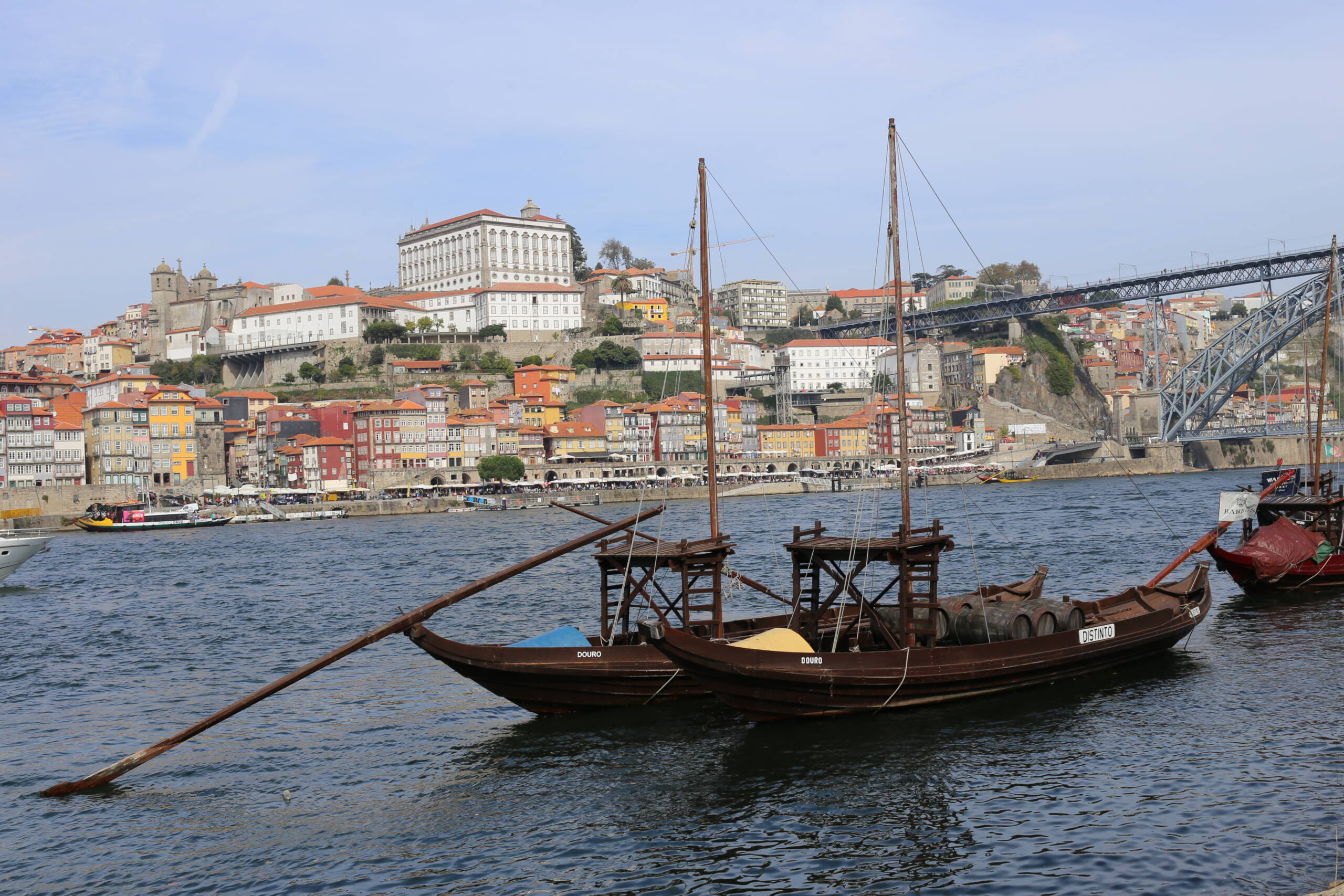
From a viewpoint like this, you can begin separating the questions that a map compresses. Which buildings are at river level? Which streets climb behind them? Where does a bridge meet the bank, and at what height? The answers matter for walking. A crossing that appears to connect two nearby points may involve a substantial approach, and a route along the water may be disconnected from the street above it.
A waterfront also provides a way to compare distances. Pick a visible landmark, walk toward it and notice how long the movement actually takes at your pace. Include the pauses, photographs and crossings that make up a real visit. After half an hour, your sense of what fits into a day will be better calibrated. Published walking times can help with planning, but they do not account for every stop or every person's needs.
The obvious route is not always the most comfortable one. A promenade can be exposed to wind, summer sun or rain, while a lower bank may involve steps and limited exits. Shared paths can carry bicycles and runners as well as visitors stopping for photographs. Check local conditions, closures and access rather than assuming the water's edge offers a continuous, level stroll. Give moving traffic and other path users enough room.
Lyon provides another version of the same opportunity. Its tourist office describes landscaped walks along the Saône that connect urban settings with quieter stretches and public art. The useful lesson is to choose a section that suits the visit. A long named waterfront project does not mean every traveler should walk its full extent, or that every section has identical access. Combine the official route information with the time and energy you have.
For photography, work with the changes in scale. A broad view explains the city, a bridge supplies structure, and a closer frame can reveal ropes, reflections or the relationship between a boat and the bank. Keep the horizon and verticals deliberate. Water can occupy a large part of the picture, so decide whether its texture contributes or merely separates the subjects you care about.
Crossing to the opposite bank can change the visual story substantially. Buildings that feel crowded from within their streets become a layered skyline; a bridge becomes a frame rather than a route overhead. Before crossing, work out the return and the practical effort involved. A distant view is more enjoyable when it does not leave you committed to an unexpectedly difficult climb.
Use the waterfront as an orientation tool, then let the streets pull you away from it. The most useful outcome may be choosing which district to explore next. Porto's river view suggests the hillside; another city may lead you toward a market, a dock neighborhood or a park. Start where the geography is readable, and the detail becomes easier to place.